
Services
- - Diagnosis, Detection and Connection
- - Analysis Laboratory
- - Application Services
- - Distribution and Deliveries
- - Grains Purchase and Sale
We are experts in information technology for nowadays agriculture

Sensing


Diagnosis

Manage

Geomarketing
 Sensing
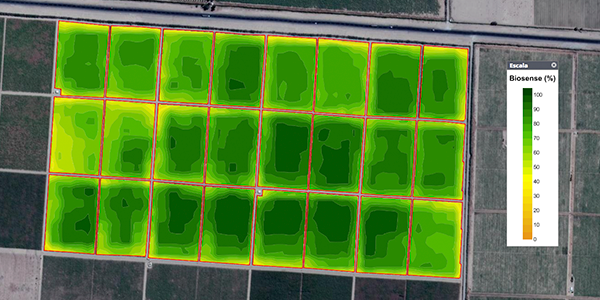
SENSING services are based on remote sensing, that is, perceiving information from the soil or plant without having physical contact with them. The technique used by Agrosat combines multiple sensors from various satellite platforms, managing to combine image sources and extracting the new info from the source data for later modeling.

CONTROL YOUR PRODUCTION EARLY.
What is it?
- Service capable of providing information on the status of biomass in a specific period of the development of a crop, fruit or forest plantation.
What is it for?
- Evaluate differences in the development of biomass in vegetative states.
- Early identification of areas with low productive potential.
- Carry out guided visits to areas of interest (low / high productive potential).
- Make corrective management to areas of low productive potential.

TOTAL EFFICIENCY!
What is it?
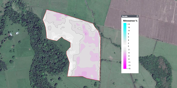
- A service that analyzes the availability of Nitrogen in the plant.
What is it for?
- Determine areas with different nitrogen absorption efficiencies.
- Obtain the kg of Nitrogen not absorbed by the plant.
- To supply Nitrogen deficiencies early.
- Asses the efficiency of Nitrogen application.
- Design more efficient Nitrogen fertilization strategies (product, dose, application date).

INTELLIGENT CLIMATE MONITORING.
What is it?
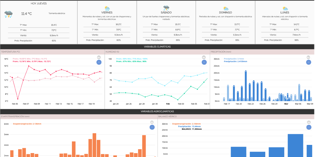
- A remote climate analysis service through the use of virtual weather stations modeled.
What is it for?
- Show future climatic conditions.
- Visualization and historical record of climatic variables (Temperature, Humidity, Radiation, Winds) and agroclimatic (Base Sum, Cold Hours, Evapotranspiration)
- Generate early phytosanitary alerts.
- Generate freeze alerts.
 Diagnosis
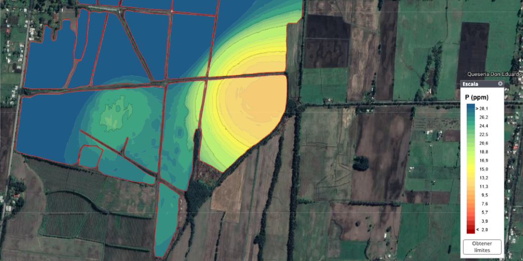
The DIAGNOSTIC services are built using a new methodology patented by the Agrosat company called Crosscheck. This service construction methodology integrates remote sensing with targeted sampling (georeferenced) and optimized location and quantity.

FERTILIZATION IS NOT A MATTER OF CHANCE.
What is it?
- It is a nutritional analysis service that determines the availability of chemical elements in the soil and plant.
What is it for?
- Determine areas of nutritional correction or maintenance.
- Design nutrition plans with selection of specific fertilizers in sources and doses.
- Enhance soil fertilization by supplementing foliarly according to deficiencies found.
- Evaluate season-to-season responses fertilizer applications.
- Implement a site-specific variable fertilization plan for critical elements.
 Manage
Agrosat MANAGEMENT services are computer platforms designed for the collection, visualization, editing and integration of strategic information of a company. They are designed, developed and implemented in total harmony with the client's need, experience and business. There are solutions available for farmers, agribusinesses and supplier companies as well as for distributors of agro-inputs.

NOTHING GETS LOST!
What is it?
- It is a digital application that collects georeferenced data from the field, associated with management practices and status of the crop.
What is it for?
- It helps to centralize all the information of tours and inspection during the growth and development of the crop.
- Facilitates the inspection of technicians or consultants to the exact places.
- Avoid data transcription and waste of time in the office.
- It allows to record and compare data collected season by season.

SUPERVISION, CONTROL AND EFFICIENCY.
What is it?
- It is a digital and intelligent field notebook, which allows agroindustries to replace their current systems for collecting information on the ground and generating recommendations, integrating easily and simply their own administrative (ERP) or business management (CRM) platforms. ), in order to always update what comes and goes from the field.
What is it for?
- Apply unified criteria in each field visit.
- Collect and update strategic information for decision making.
- Centralize the information collected.
- Follow up on agricultural work days and tasks.
- Generate automatic alerts and notifications.

INSTANT INFORMATION!
What is it?
- It is a web and online platform that allows the storage, visualization and editing of all the information generated from Agrosat services.
What is it for?
- Visualization and comparison of information on maps, scales and statistics obtained from each service.
- Basic editing of parameters and visualizations.
- Generation of automatic reports.
- Storage and display of information differentiated by type of user.
 Geomarketing
GEOMARKETING services allow you to visualize properties or numerical information of an object in a spatial way, by assigning a coordinate, which facilitates not only the visual interpretation, but also the possible dependency relationships found on them and other layers of information. These geographic variables condition a new type of analysis for decision-making in the business, where the location and segmentation of the processed information will optimize commercial, operational and financial campaigns.

KNOWLEDGE IS POWER
What is it?
- It is a service that allows spatially identifying in number and location, crops, fruit trees or other agricultural holdings.
What is it for?
- Quantify areas sown or planted by areas of interest.
- Identify the spatial distribution of crops or plantations.
- Analyze areas sown or planted by different political or commercial divisions.
- Plan sales campaigns, technical assistance and marketing of agro-supplies according to the results obtained.

BETTER INFORMATION, BETTER DECISION.
What is it?
- It is an inspection service that analyzes historical edapho-agro-climatic variables of a particular area.
What is it for?
- Identify the most critical productive variables by type of working.
- Evaluate agronomic or forestry feasibility for productive investment projects.
- Determine the best crop or fruit tree for that analyzed area.
- Compare different areas for purchase or lease and select the less critical.